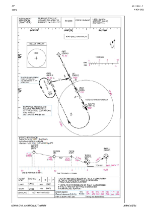


HKLU - Lamu Manda
Located in Lamu Manda, Kenya
ICAO - HKLU, IATA - LAU
Data provided by AirmateGeneral information
Coordinates: S2°15'8" E40°54'47"
Elevation is 18 feet MSL.
Magnetic variation is -1° East View others Airports in Coast Province
Operational data
Special qualification required
Current time UTC:
Current local time:
Weather
METAR: HKLU 181000Z 00000KT 9999 FEW024CB SCT024 BKN080 28/25 Q1011
Communications frequencies: [VIEW]
Runways:
| RWY identifier | QFU | Length (ft) | Width (ft) | Surface | LDA (ft) |
| 08 | 74° | 3130 | 76 | DIRT | 2963 |
| 26 | 254° | 3130 | 76 | DIRT | 2963 |
| 15 | 153° | 6565 | 104 | ASPH | 6562 |
| 33 | 333° | 6565 | 104 | ASPH | 6562 |
Airport contact information
Address: Lamu Manda Kenya