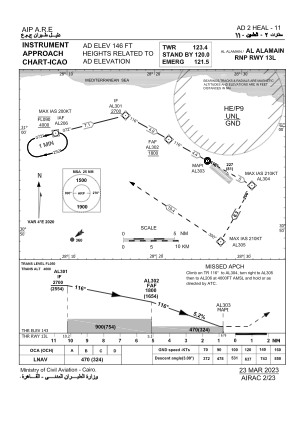
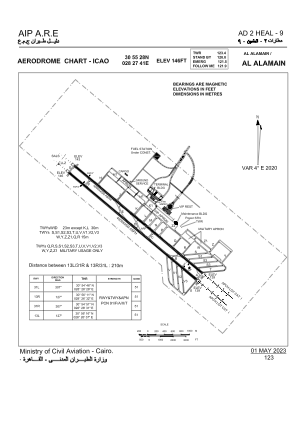


HEAL - Al Alamain / Intl
Located in New Al Alamain, Egypt
ICAO - HEAL, IATA - DBB
Data provided by AirmateGeneral information
Coordinates: N30°55'28" E28°27'41"
Elevation is 146 feet MSL.
View others Airports in Matruh Governorate
Operational data
Special qualification required
Current time UTC:
Current local time:
Weather
TAF: TAF HEAL 251100Z 2512/2618 32015KT 9999 SCT020
Communications frequencies: [VIEW]
Runways:
| RWY identifier | QFU | Length (ft) | Width (ft) | Surface | LDA (ft) |
| 13L | 131° | 13123 | 148 | UNK | |
| 31R | 311° | 13123 | 148 | UNK | |
| 13R | 131° | 13123 | 148 | UNK | |
| 31L | 311° | 13123 | 148 | UNK |
Airport contact information
Address: New Al Alamain Egypt