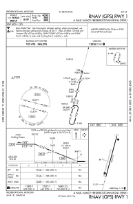
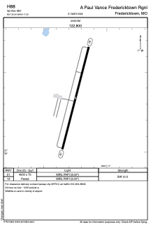


H88 - A Paul Vance Fredericktown Rgnl
Located in Fredericktown, United States
ICAO - H88, IATA -
Data provided by AirmateGeneral information
Coordinates: N37°36'20" W90°17'15"
Elevation is 880 feet MSL.
Magnetic variation is 00° East View others Airports in Missouri
Operational data
Special qualification required
Current time UTC:
Current local time:
Weather at : KFAM - Farmington Rgnl ( 21 km )
METAR: KFAM 200556Z AUTO 00000KT 10SM OVC110 07/04 A3024 RMK AO2 SLP252 T00670039 10139 20061 401560061 58002
Communications frequencies: [VIEW]
Runways:
| RWY identifier | QFU | Length (ft) | Width (ft) | Surface | LDA (ft) |
| 01 | 15° | 4000 | 75 | ASPH | |
| 19 | 195° | 4000 | 75 | ASPH |
Airport contact information
Address: Fredericktown United States