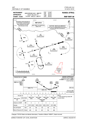


FYRU - Rundu
Located in Rundu, Namibia
ICAO - FYRU, IATA - NDU
Data provided by AirmateGeneral information
Coordinates: S17°57'22" E19°43'14"
Elevation is 3627 feet MSL.
View others Airports in Okavango
Operational data
Special qualification required
Current time UTC:
Current local time:
Weather
TAF: TAF FYRU 200200Z 2003/2012 10005KT CAVOK
Communications frequencies: [VIEW]
Runways:
| RWY identifier | QFU | Length (ft) | Width (ft) | Surface | LDA (ft) |
| 08 | 72° | 11004 | 98 | ASP | |
| 26 | 252° | 11004 | 98 | ASP |
Airport contact information
Address: Rundu Namibia