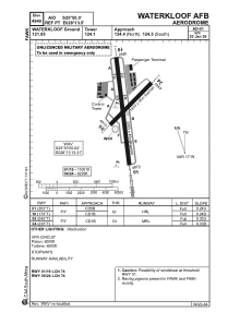


FAWK - Waterkloof Afb (Mil - Unlicensed)
Located in Lyttelton, South Africa
ICAO - FAWK, IATA - WKF
Data provided by AirmateGeneral information
Coordinates: S25°49'42" E28°13'26"
Elevation is 4940 feet MSL.
Magnetic variation is -18° East View others Airports in Gauteng
Operational data
Special qualification required
Current time UTC:
Current local time:
Weather at : FALA - Lanseria International ( 32 km )
METAR: FALA 180400Z 00000KT CAVOK 11/09 Q1028 NOSIG
TAF: TAF FALA 180400Z 1806/1906 VRB03KT CAVOK TX23/1812Z TN12/1904Z
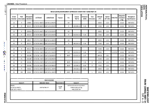
Communications frequencies: [VIEW]
Runways:
| RWY identifier | QFU | Length (ft) | Width (ft) | Surface | LDA (ft) |
| 01 | 352° | 11021 | 145 | ASPH | 10991 |
| 19 | 172° | 11021 | 145 | ASPH | 10991 |
| 06 | 45° | 6261 | 142 | ASPH | 6293 |
| 24 | 225° | 6261 | 142 | ASPH | 6293 |
Airport contact information
Address: Lyttelton South Africa