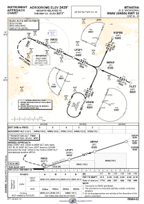
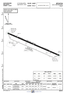


FAUT - Mthatha
Located in Umtata, South Africa
ICAO - FAUT, IATA - UTT
Data provided by AirmateGeneral information
Coordinates: S31°32'46" E28°40'31"
Elevation is 2429 feet MSL.
Magnetic variation is -27° East View others Airports in Eastern Cape
Operational data
Special qualification required
Current time UTC:
Current local time:
Communications frequencies: [VIEW]
Runways:
| RWY identifier | QFU | Length (ft) | Width (ft) | Surface | LDA (ft) |
| 14 | 113° | 8502 | 156 | ASPH | 8530 |
| 32 | 293° | 8502 | 156 | ASPH | 8530 |
Airport contact information
Address: Umtata South Africa