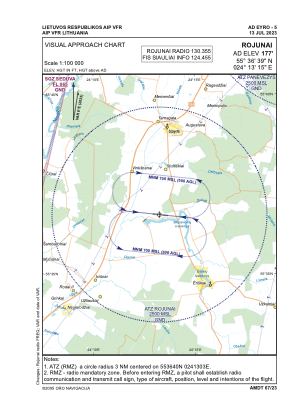


EYRO - Rojunai
Located in Panevezys, Lithuania
ICAO - EYRO, IATA -
Data provided by AirmateGeneral information
Coordinates: N55°36'39" E24°13'15"
Elevation is 177 feet MSL.
Magnetic variation is 8° East View others Airports in Panevežys County
Operational data
Special qualification required
Current time UTC:
Current local time:
Weather at : EYSA - Siauliai/Military/International ( 60 km )
METAR: EYSA 230820Z 23010KT 9999 FEW007 BKN030 00/00 Q1017 TEMPO BKN005
TAF: TAF EYSA 230800Z 2309/2318 23010KT 9000 SCT010 OVC020 TEMPO 2309/2318 3000 SHSNRA BKN005 BKN015CB
Communications frequencies: [VIEW]
Runways:
| RWY identifier | QFU | Length (ft) | Width (ft) | Surface | LDA (ft) |
| 09 | 96° | 2559 | 131 | GRASS | |
| 27 | 276° | 2559 | 131 | GRASS |
Airport contact information
Address: Panevezys Lithuania