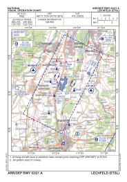

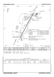


ETSL - Lechfeld
Located in Lagerlechfeld, Germany
ICAO - ETSL, IATA -
Data provided by AirmateGeneral information
Coordinates: N48°11'8" E10°51'40"
Elevation is 1822 feet MSL.
Magnetic variation is 3.82° East View others Airports in Bavaria
Operational data
Special qualification required
Current time UTC:
Current local time:
Weather
METAR: ETSL 191320Z AUTO 22022G34KT 9999 // ////// 05/01 Q1011 ///
Communications frequencies: [VIEW]
Runways:
| RWY identifier | QFU | Length (ft) | Width (ft) | Surface | LDA (ft) |
| 03 | 29° | 8787 | 98 | ASPH | 8787 |
| 21 | 209° | 8787 | 98 | ASPH | 8787 |
Airport contact information
Address: Lagerlechfeld Germany
Other aviation service providers
Aviation club (not for profit)

Bundeswehr-Sportflieger-Gemeinschaft Fürstenfeldbruck E.V.
Bundeswehr-Sportflieger-Gemeinschaft Fürstenfeldbruck E.V.
info@fursty.de+49814191342