
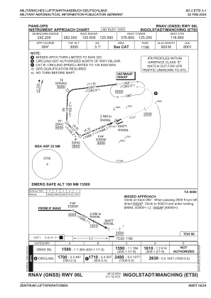


ETSI - Ingolstadt/Manching
Located in Ingolstadt, Manching, Germany
ICAO - ETSI, IATA - IGS
Data provided by AirmateGeneral information
Coordinates: N48°42'56" E11°32'1"
Elevation is 1203 feet MSL.
Magnetic variation is 4° East View others Airports in Bavaria
Operational data
Special qualification required
Current time UTC:
Current local time:
Weather
METAR: ETSI 200420Z AUTO 28009KT //// // ////// 04/02 Q1011 ///
Communications frequencies: [VIEW]
Runways:
| RWY identifier | QFU | Length (ft) | Width (ft) | Surface | LDA (ft) |
| 06L | 68° | 8001 | 98 | CONC | 8001 |
| 24R | 248° | 8001 | 98 | CONC | 8001 |
| 06R | 68° | 9646 | 197 | CONC | 9646 |
| 24L | 248° | 9646 | 197 | CONC | 9646 |
Airport contact information
Address: Ingolstadt, Manching Germany
