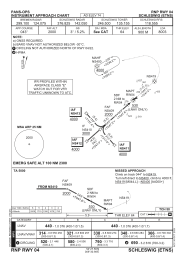
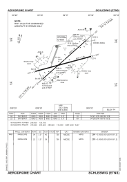


ETNS - Schleswig
Located in Schleswig, Germany
ICAO - ETNS, IATA - WBG
Data provided by AirmateGeneral information
Coordinates: N54°27'34" E9°30'59"
Elevation is 74 feet MSL.
Magnetic variation is 3.69° East View others Airports in Schleswig-Holstein
Operational data
Special qualification required
Current time UTC:
Current local time:
Weather
METAR: ETNS 182320Z AUTO 18005KT //// // ////// 05/04 Q1010 ///
TAF: TAF COR ETNS 181339Z 1814/1823 27012KT 9999 NSW BKN040 BKN180 TEMPO 1814/1818 28015G25KT 9999 NSW SCT040 SCT200
Communications frequencies: [VIEW]
Runways:
| RWY identifier | QFU | Length (ft) | Width (ft) | Surface | LDA (ft) |
| 07 | 74° | 8071 | 144 | CONC+ASPH | 8071 |
| 25 | 254° | 8071 | 144 | CONC+ASPH | 8071 |
| 05 | 48° | 8003 | 98 | CONC+ASPH | 8003 |
| 23 | 228° | 8003 | 98 | CONC+ASPH | 8003 |
Airport contact information
Address: Schleswig Germany