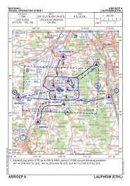
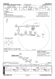
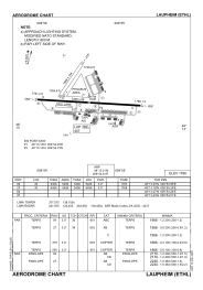


ETHL - Laupheim
Located in Laupheim, Germany
ICAO - ETHL, IATA -
Data provided by AirmateGeneral information
Coordinates: N48°13'12" E9°54'37"
Elevation is 1766 feet MSL.
Magnetic variation is 3.59° East View others Airports in Baden-Württemberg
Operational data
Special qualification required
Current time UTC:
Current local time:
Weather
METAR: ETHL 251620Z 24006KT 9999 FEW040 SCT070 09/M02 Q1006 BLU+BLU BECMG BLU+
TAF: TAF ETHL 251616Z 2517/2602 25008KT 9999 NSW FEW040 BKN060 BECMG 2517/2519 15004KT 9999 NSW FEW060
Communications frequencies: [VIEW]
Runways:
| RWY identifier | QFU | Length (ft) | Width (ft) | Surface | LDA (ft) |
| 09 | 93° | 5406 | 98 | BITUM | 5406 |
| 27 | 273° | 5406 | 98 | BITUM | 5406 |
| 03 | 34° | 1968 | 164 | GRASS | 1968 |
| 21 | 214° | 1968 | 164 | GRASS | 1968 |
Airport contact information
Address: Laupheim Germany
Other aviation service providers
Aviation club (not for profit)

Bundeswehr-Luftsportring Laupheim E.V.
Bundeswehr-Luftsportring Laupheim E.V.
info@luftsportring.de+4973925707
Luftsportverein Diehl Aircabin Laupheim E.V.
Luftsportverein Diehl Aircabin Laupheim E.V.
lsv.diehl.aircabin@t-online.de+4973925974