


EPIR - Inowroclaw
Located in Inowroclaw, Poland
ICAO - EPIR, IATA -
Data provided by AirmateGeneral information
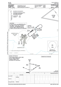
Coordinates: N52°49'43" E18°19'49"
Elevation is 276 feet MSL.
Magnetic variation is 6.0000° East View others Airports in Kuyavia-Pomerania
Operational data
Special qualification required
Current time UTC:
Current local time:
Weather
TAF: TAF AMD EPIR 251010Z 2506/2518 24018KT 9999 BKN040 TEMPO 2510/2518 25022G32KT SHRA SCT015CB PROB30 TEMPO 2513/2518 VRB26G36KT 4000 TSRA BKN015CB
Communications frequencies: [VIEW]
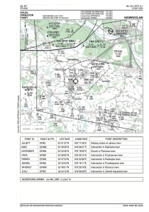
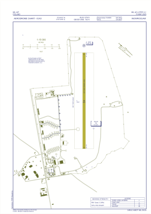
Runways:
| RWY identifier | QFU | Length (ft) | Width (ft) | Surface | LDA (ft) |
| 05 | 52° | 6562 | 197 | GRASS | 6562 |
| 23 | 232° | 6562 | 197 | GRASS | 6562 |
Airport contact information
Address: Inowroclaw Poland
