
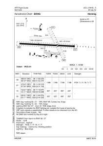


EKHG - Herning
Located in Herning, Denmark
ICAO - EKHG, IATA -
Data provided by AirmateGeneral information
Coordinates: N56°11'5" E9°2'40"
Elevation is 167 feet MSL.
Magnetic variation is +1.2° East View others Airports in Central Jutland
Operational data
Special qualification required
Current time UTC:
Current local time:
Weather at : EKKA - Karup / Midtjyllands Lufthavn (Mil/Civ) ( 13 km )
METAR: EKKA 232120Z AUTO 02002KT 9999 -RA OVC023/// 04/04 Q1006
TAF: TAF EKKA 232007Z 2321/2421 VRB05KT 9999 SCT008 BKN020 TEMPO 2321/2407 2000 -SHRA BR BKN003 FEW020CB BECMG 2400/2403 07008KT TEMPO 2407/2421 5000 SHRA SCT020CB
Communications frequencies: [VIEW]
Runways:
| RWY identifier | QFU | Length (ft) | Width (ft) | Surface | LDA (ft) |
| 09 | 0° | 3934 | 98 | UNK | |
| 27 | 0° | 3934 | 98 | UNK | |
| 15 | 0° | 2188 | 98 | UNK | |
| 33 | 0° | 2188 | 98 | UNK |
Airport contact information
Address: Herning Denmark
