


EHDR - Drachten/Drachten
Located in Drachten, Netherlands
ICAO - EHDR, IATA -
Data provided by AirmateGeneral information
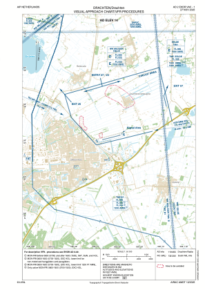
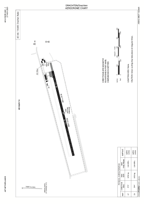
Coordinates: N53°7'5" E6°7'45"
Elevation is 14 feet MSL.
Magnetic variation is 1.9289° East View others Airports in Friesland
Operational data
Special qualification required
Current time UTC:
Current local time:
Weather at : EHLW - Leeuwarden/Leeuwarden ( 28 km )
METAR: EHLW 200200Z AUTO 36014KT 9999 -RA FEW015CB BKN028 OVC031 06/04 Q1016 BLU
TAF: TAF EHLW 200039Z 2001/2013 34012G22KT 9999 FEW020 SCT030 TEMPO 2001/2013 35015G27KT 4500 SHRA SCT015 SCT020CB BKN022
Communications frequencies: [VIEW]
Runways:
| RWY identifier | QFU | Length (ft) | Width (ft) | Surface | LDA (ft) |
| 07 | 77° | 2395 | 79 | CONC+ASPH | |
| 25 | 257° | 2395 | 79 | CONC+ASPH |
Airport contact information
Address: Drachten Netherlands
