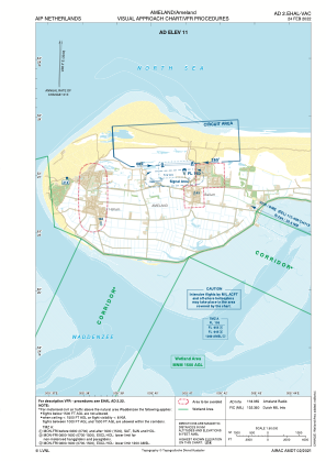


EHAL - Ameland/Ameland
Located in Ameland, Netherlands
ICAO - EHAL, IATA -
Data provided by AirmateGeneral information
Coordinates: N53°27'6" E5°40'38"
Elevation is 11 feet MSL.
Magnetic variation is 1.7684° East View others Airports in Friesland
Operational data
Special qualification required
Current time UTC:
Current local time:
Weather at : EHMA - Awg-1 ( 18 km )
METAR: EHMA 191925Z AUTO 35029KT 9999 FEW022 SCT025 BKN038 08/03 Q1011
Communications frequencies: [VIEW]
Runways:
| RWY identifier | QFU | Length (ft) | Width (ft) | Surface | LDA (ft) |
| 08 | 87° | 2822 | 98 | GRASS | |
| 26 | 267° | 2822 | 98 | GRASS |
Airport contact information
Address: Ameland Netherlands
Other aviation service providers
Flight schools

Vliegbedrijf Tom Van Der Meulen B.V.
Vliegbedrijf Tom Van Der Meulen B.V.
info@ameland-rondvluchten.nl+31519554644
+31646015504
+31646015504