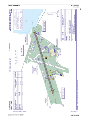


EGAE - Londonderry/Eglinton
Located in Londonderry, United Kingdom
ICAO - EGAE, IATA - LDY
Data provided by AirmateGeneral information
Coordinates: N55°2'34" W7°9'43"
Elevation is 23 feet MSL.
View others Airports in Northern Ireland
Operational data
Special qualification required
Current time UTC:
Current local time:
Weather
TAF: TAF EGAE 181657Z 1818/1822 27013KT 9999 BKN025 TEMPO 1818/1822 6000 RA -RADZ BKN010 PROB30 TEMPO 1818/1822 3000 RADZ BKN004
Communications frequencies: [VIEW]
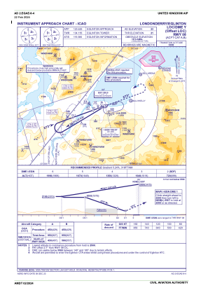
Runways:
| RWY identifier | QFU | Length (ft) | Width (ft) | Surface | LDA (ft) |
| 08 | 73° | 6460 | 148 | ASP | |
| 26 | 253° | 6460 | 148 | ASP |
Airport contact information
Address: Londonderry United Kingdom

