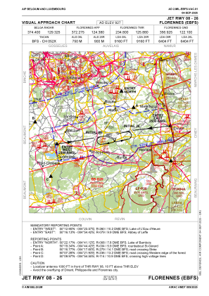
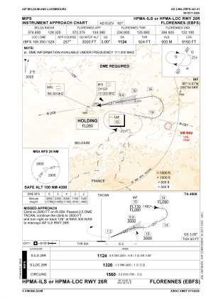
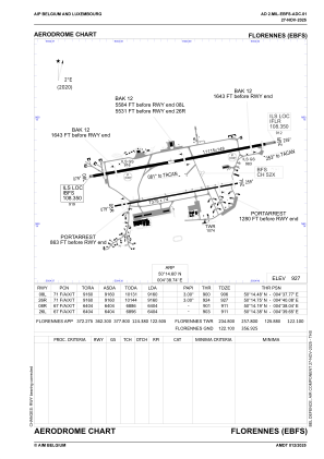


EBFS - Florennes
Located in Florennes, Belgium
ICAO - EBFS, IATA -
Data provided by AirmateGeneral information
Coordinates: N50°14'36" E4°38'45"
Elevation is 927 feet MSL.
Magnetic variation is 2° East View others Airports in Namur
Operational data
Special qualification required
Current time UTC:
Current local time:
Weather
TAF: TAF AMD EBFS 250917Z 2510/2519 25010KT 9999 SCT025 SCT030 BKN200 BECMG 2510/2512 22010KT TEMPO 2512/2516 22010G20KT
Communications frequencies: [VIEW]
Runways:
| RWY identifier | QFU | Length (ft) | Width (ft) | Surface | LDA (ft) |
| 08L | 80° | 11115 | 148 | ASPH | 8648 |
| 26R | 260° | 11115 | 148 | ASPH | 8763 |
| 08R | 80° | 7375 | 75 | ASPH | 5965 |
| 26L | 260° | 7375 | 75 | ASPH | 6027 |
Airport contact information
Address: Florennes Belgium
Other aviation service providers
Aviation club (not for profit)

Royal Belgian Defence Aeroclub
Royal Belgian Defence Aeroclub
comopsair-avia-secretariaat@mil.be+3224419073