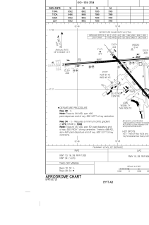


CYYT - St. John's Intl
Located in St. John's, Canada
ICAO - CYYT, IATA - YYT
Data provided by AirmateGeneral information
Coordinates: N47°37'7" W52°45'9"
Elevation is 461 feet MSL.
Magnetic variation is -19.1333° East View others Airports in Newfoundland and Labrador
Operational data
Special qualification required
Current time UTC:
Current local time:
Weather
TAF: TAF AMD CYYT 191341Z 1913/2012 02020G35KT 3/4SM BR VV002 TEMPO 1913/1917 6SM -SN OVC008 PROB30 1913/1917 2SM -FZDZ BR FM191700 01020G35KT 6SM BR BKN008 TEMPO 1917/1919 BKN015 FM191900 01020G30KT P6SM BKN015 BECMG 1922/1924 02015G25KT FM200300 36012KT P6SM SCT006 BKN010 FM201100 VRB03KT P6SM SCT010 RMK NXT FCST BY 191800Z
Communications frequencies: [VIEW]
Runways:
| RWY identifier | QFU | Length (ft) | Width (ft) | Surface | LDA (ft) |
| 11 | 86° | 8502 | 200 | ASPH | 8502 |
| 29 | 266° | 8502 | 200 | ASPH | 8502 |
| 16 | 139° | 7005 | 200 | ASPH | 7005 |
| 34 | 319° | 7005 | 200 | ASPH | 7005 |
Airport contact information
Address: St. John's Canada