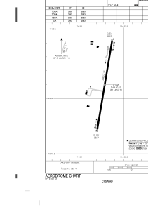


CYSW - Elk Valley
Located in Sparwood, Canada
ICAO - CYSW, IATA -
Data provided by AirmateGeneral information
Coordinates: N49°50'0" W114°53'4"
Elevation is 3800 feet MSL.
Magnetic variation is 14.9667° East View others Airports in British Columbia
Operational data
Special qualification required
Current time UTC:
Current local time:
Weather at : CYXC - Canadian Rockies Intl ( 69 km )
METAR: CYXC 232000Z VRB06KT 25SM FEW080 FEW250 15/M05 A3001 RMK CU1CI2 CU TR SLP174 DENSITY ALT 3700FT
TAF: TAF CYXC 231840Z 2319/2407 VRB03KT P6SM FEW060 SCT240 BECMG 2319/2321 08008KT RMK NXT FCST BY 240100Z
Communications frequencies: [VIEW]
Runways:
| RWY identifier | QFU | Length (ft) | Width (ft) | Surface | LDA (ft) |
| 17 | 0° | 4000 | 75 | ASPH | |
| 35 | 0° | 4000 | 75 | ASPH |
Airport contact information
Address: Sparwood Canada