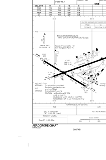


CYQT - Thunder Bay
Located in Thunder Bay, Canada
ICAO - CYQT, IATA - YQT
Data provided by AirmateGeneral information
Coordinates: N48°22'19" W89°19'26"
Elevation is 654 feet MSL.
Magnetic variation is -03° East View others Airports in Ontario
Operational data
Special qualification required
Current time UTC:
Current local time:
Weather
METAR: CYQT 251600Z 07010KT 20SM SKC 05/M02 A3030 RMK SLP272
TAF: TAF CYQT 251340Z 2514/2602 VRB03KT P6SM SKC BECMG 2515/2517 11012KT BECMG 2600/2602 07005KT RMK NXT FCST BY 252000Z
Communications frequencies: [VIEW]
Runways:
| RWY identifier | QFU | Length (ft) | Width (ft) | Surface | LDA (ft) |
| 07 | 71° | 6200 | 200 | ASPH | 7318 |
| 25 | 251° | 6200 | 200 | ASPH | 7318 |
| 12 | 121° | 5300 | 200 | ASPH | 5297 |
| 30 | 301° | 5300 | 200 | ASPH | 5126 |
Airport contact information
Address: Thunder Bay Canada
Other aviation service providers
Flight schools

Confederation College
Confederation College
Rick.Stewart@confederationcollege.ca+18074732418
+18074732418
+18074732418