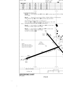


CYQL - Lethbridge
Located in , Canada
ICAO - CYQL, IATA - YQL
Data provided by AirmateGeneral information
Coordinates: N49°37'49" W112°47'59"
Elevation is 3049 feet MSL.
Magnetic variation is 13.6778° East View others Airports in Alberta
Operational data
Special qualification required
Current time UTC:
Current local time:
Weather
METAR: CYQL 200800Z AUTO 19003KT 9SM CLR M07/M10 A3041 RMK SLP348
TAF: TAF CYQL 200545Z 2006/2018 14008KT P6SM SKC BECMG 2010/2012 19006KT BECMG 2015/2017 16012KT RMK FCST BASED ON AUTO OBS. NXT FCST BY 201200Z
Communications frequencies: [VIEW]
Runways:
| RWY identifier | QFU | Length (ft) | Width (ft) | Surface | LDA (ft) |
| 06 | 70° | 6500 | 200 | ASPH | 6500 |
| 24 | 250° | 6500 | 200 | ASPH | 6500 |
| 13 | 140° | 5500 | 150 | ASPH | 5500 |
| 31 | 320° | 5500 | 150 | ASPH | 5500 |
Airport contact information
Address: Canada

