


CNH2 - Natuashish
Located in , Canada
ICAO - CNH2, IATA -
Data provided by AirmateGeneral information
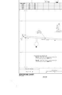
Coordinates: N55°54'50" W61°11'4"
Elevation is 33 feet MSL.
Magnetic variation is -21.3343° East View others Airports in Newfoundland and Labrador
Operational data
Special qualification required
Current time UTC:
Current local time:
Weather at : CYDP - Nain ( 77 km )
METAR: CYDP 201200Z 19010G17KT 15SM -SHRA OVC051 04/M02 A2937 RMK SC8 SLP949
TAF: TAF CYDP 200940Z 2010/2022 VRB03KT P6SM OVC040 TEMPO 2010/2011 P6SM -FZRA FM201100 19008G18KT P6SM -SNRA OVC030 BECMG 2012/2014 19015G25KT FM201600 19015KT P6SM BKN030 TEMPO 2020/2022 P6SM -SHRA BKN020 RMK NXT FCST BY 201400Z
Communications frequencies: [VIEW]
Runways:
| RWY identifier | QFU | Length (ft) | Width (ft) | Surface | LDA (ft) |
| 12 | 95° | 2500 | 75 | GRAVE | 2500 |
| 30 | 275° | 2500 | 75 | GRAVE | 2500 |
Airport contact information
Address: Canada