


92C - Carter
Located in Pulaski, United States
ICAO - 92C, IATA -
Data provided by AirmateGeneral information
Coordinates: N44°38'28" W88°12'52"
Elevation is 782 feet MSL.
Magnetic variation is -02° East View others Airports in Wisconsin
Operational data
Special qualification required
Current time UTC:
Current local time:
Weather at : KGRB - Green Bay/Austin Straubel Intl ( 19 km )
METAR: KGRB 250553Z AUTO 00000KT 10SM CLR M01/M04 A3033 RMK AO2 SLP277 T10061039 10089 21006 400941017 51007
TAF: KGRB 250520Z 2506/2606 12004KT P6SM BKN250 FM251600 15008KT P6SM SKC FM260100 11005KT P6SM SKC
Communications frequencies: [VIEW]
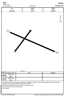
Runways:
| RWY identifier | QFU | Length (ft) | Width (ft) | Surface | LDA (ft) |
| 03 | 0° | 1610 | 80 | GRASS | |
| 21 | 0° | 1610 | 80 | GRASS | |
| 12 | 114° | 2955 | 38 | ASPH | |
| 30 | 294° | 2955 | 38 | ASPH |
Airport contact information
Address: Pulaski United States