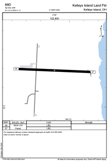


89D - Kelleys Island Land Fld
Located in Kelleys Island, United States
ICAO - 89D, IATA -
Data provided by AirmateGeneral information
Coordinates: N41°36'11" W82°41'6"
Elevation is 598 feet MSL.
Magnetic variation is -07° East View others Airports in Ohio
Operational data
Special qualification required
Current time UTC:
Current local time:
Weather at : KPCW - Erie-Ottawa Intl ( 18 km )
METAR: KPCW 251335Z AUTO 32004KT 10SM CLR 05/M00 A3037 RMK AO2
Communications frequencies: [VIEW]
Runways:
| RWY identifier | QFU | Length (ft) | Width (ft) | Surface | LDA (ft) |
| 09 | 92° | 2202 | 50 | ASPH | |
| 27 | 272° | 2202 | 50 | ASPH |
Airport contact information
Address: Kelleys Island United States