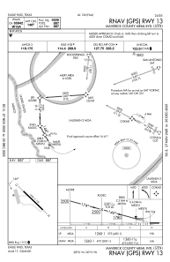


5T9 - Maverick County Meml Intl
Located in Eagle Pass, United States
ICAO - 5T9, IATA -
Data provided by AirmateGeneral information
Coordinates: N28°51'26" W100°30'48"
Elevation is 887 feet MSL.
Magnetic variation is 06° East View others Airports in Texas
Operational data
Special qualification required
Current time UTC:
Current local time:
Weather at : MMPG - Piedras Negras Aeropuerto Internacional ( 26 km )
TAF: TAF MMPG 171727Z 1718/1818 12010KT 5SM HZ SCT025 BKN250 PROB40 1723/1803 18015G30KT 3SM TSRA BKN020CB FM180600 00000KT 5SM HZ BKN015 FM181200 00000KT 2SM BR BKN005 OVC010 FM181500 00000KT 4SM HZ BKN010
Communications frequencies: [VIEW]
Runways:
| RWY identifier | QFU | Length (ft) | Width (ft) | Surface | LDA (ft) |
| 13 | 135° | 5506 | 100 | ASPH | |
| 31 | 315° | 5506 | 100 | ASPH |
Airport contact information
Address: Eagle Pass United States