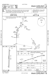


50R - Lockhart Muni
Located in Lockhart, United States
ICAO - 50R, IATA -
Data provided by AirmateGeneral information
Coordinates: N29°51'1" W97°40'21"
Elevation is 532 feet MSL.
Magnetic variation is 07° East View others Airports in Texas
Operational data
Special qualification required
Current time UTC:
Current local time:
Weather at : KHYI - San Marcos Rgnl ( 19 km )
METAR: KHYI 191256Z 12003KT 7SM SCT004 BKN015 OVC028 21/21 A3003 RMK AO2 SLP162 T02110211
Communications frequencies: [VIEW]
Runways:
| RWY identifier | QFU | Length (ft) | Width (ft) | Surface | LDA (ft) |
| 18 | 182° | 4001 | 75 | ASPH | |
| 36 | 2° | 4001 | 75 | ASPH |
Airport contact information
Address: Lockhart United States
