


50D - Iron County
Located in Crystal Falls, United States
ICAO - 50D, IATA -
Data provided by AirmateGeneral information
Coordinates: N46°0'33" W88°16'26"
Elevation is 1340 feet MSL.
Magnetic variation is -02° East View others Airports in Michigan
Operational data
Special qualification required
Current time UTC:
Current local time:
Weather at : KIMT - Ford ( 25 km )
METAR: KIMT 250754Z AUTO 00000KT 10SM CLR M04/M09 A3029 RMK AO2 SLP271 T10441089
Communications frequencies: [VIEW]
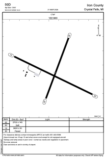
Runways:
| RWY identifier | QFU | Length (ft) | Width (ft) | Surface | LDA (ft) |
| 02 | 20° | 2700 | 145 | GRASS | |
| 20 | 200° | 2700 | 145 | GRASS | |
| 12 | 116° | 3690 | 50 | ASPH | |
| 30 | 296° | 3690 | 50 | ASPH |
Airport contact information
Address: Crystal Falls United States