


4V8 - Deerfield Valley Rgnl
Located in West Dover, United States
ICAO - 4V8, IATA -
Data provided by AirmateGeneral information
Coordinates: N42°55'38" W72°51'56"
Elevation is 1953 feet MSL.
Magnetic variation is -15° East View others Airports in Vermont
Operational data
Special qualification required
Current time UTC:
Current local time:
Weather at : KDDH - William H Morse State ( 31 km )
METAR: KDDH 250554Z AUTO 00000KT 10SM CLR M02/M05 A3022 RMK AO2 SLP240 T10171050 10044 21028 53019
Communications frequencies: [VIEW]
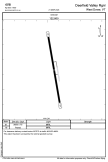
Runways:
| RWY identifier | QFU | Length (ft) | Width (ft) | Surface | LDA (ft) |
| 01 | 350° | 2650 | 75 | ASPH | |
| 19 | 170° | 2650 | 75 | ASPH |
Airport contact information
Address: West Dover United States