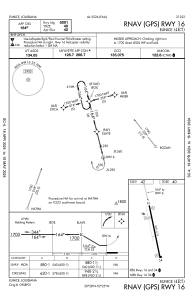


4R7 - Eunice
Located in Eunice, United States
ICAO - 4R7, IATA -
Data provided by AirmateGeneral information
Coordinates: N30°27'59" W92°25'26"
Elevation is 42 feet MSL.
Magnetic variation is 02° East View others Airports in Louisiana
Operational data
Special qualification required
Current time UTC:
Current local time:
Weather at : KOPL - St Landry Parish-Ahart Fld ( 33 km )
METAR: KOPL 190250Z AUTO 14005KT 10SM CLR 23/21 A3001 RMK AO2 LTG DSNT NE T02270205
Communications frequencies: [VIEW]
Runways:
| RWY identifier | QFU | Length (ft) | Width (ft) | Surface | LDA (ft) |
| 16 | 166° | 5001 | 75 | ASPH | |
| 34 | 346° | 5001 | 75 | ASPH |
Airport contact information
Address: Eunice United States
