


4G3 - Miller
Located in Alliance, United States
ICAO - 4G3, IATA -
Data provided by AirmateGeneral information
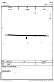
Coordinates: N40°58'54" W81°2'32"
Elevation is 1071 feet MSL.
Magnetic variation is -04° East View others Airports in Ohio
Operational data
Special qualification required
Current time UTC:
Current local time:
Weather at : KPOV - Portage County ( 31 km )
METAR: KPOV 200015Z AUTO 26006KT 10SM CLR 12/01 A3002 RMK AO2 T01210011 PWINO
Communications frequencies: [VIEW]
Runways:
| RWY identifier | QFU | Length (ft) | Width (ft) | Surface | LDA (ft) |
| 09 | 91° | 2912 | 50 | ASPH | |
| 27 | 271° | 2912 | 50 | ASPH |
Airport contact information
Address: Alliance United States