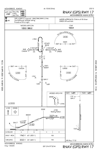


47K - Moundridge Muni
Located in Moundridge, United States
ICAO - 47K, IATA -
Data provided by AirmateGeneral information
Coordinates: N38°12'33" W97°30'10"
Elevation is 1489 feet MSL.
Magnetic variation is 07° East View others Airports in Kansas
Operational data
Special qualification required
Current time UTC:
Current local time:
Weather at : KMPR - Mc Pherson ( 23 km )
METAR: KMPR 161855Z AUTO 23029G34KT 10SM CLR 25/05 A2950 RMK AO2 T02550055
Communications frequencies: [VIEW]
Runways:
| RWY identifier | QFU | Length (ft) | Width (ft) | Surface | LDA (ft) |
| 17 | 180° | 3405 | 50 | ASPH | |
| 35 | 0° | 3405 | 50 | ASPH |
Airport contact information
Address: Moundridge United States