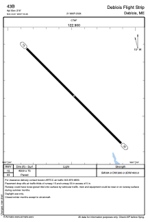


43B - Deblois Flight Strip
Located in Deblois, United States
ICAO - 43B, IATA -
Data provided by AirmateGeneral information
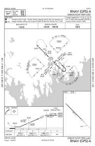
Coordinates: N44°43'37" W67°59'29"
Elevation is 218 feet MSL.
Magnetic variation is -16° East View others Airports in Maine
Operational data
Special qualification required
Current time UTC:
Current local time:
Weather at : KBHB - Hancock County/Bar Harbor ( 43 km )
TAF: KBHB 241120Z 2412/2512 17007KT P6SM BKN070 FM241900 20010G20KT 5SM -RA BR OVC023 FM242000 21010G19KT 6SM BR VCSH BKN015 FM242200 27010G20KT P6SM BKN015 FM242300 30011G22KT P6SM BKN029 FM250000 31013G26KT P6SM SCT090
Communications frequencies: [VIEW]
Runways:
| RWY identifier | QFU | Length (ft) | Width (ft) | Surface | LDA (ft) |
| 15 | 135° | 4500 | 75 | ASPH | |
| 33 | 315° | 4500 | 75 | ASPH |
Airport contact information
Address: Deblois United States