


16KS - Harmony Valley
Located in Independence, United States
ICAO - 16KS, IATA -
Data provided by AirmateGeneral information
Coordinates: N37°13'24" W95°35'53"
Elevation is 780 feet MSL.
View others Airports in Kansas
Operational data
Special qualification required
Current time UTC:
Current local time:
Weather at : KPPF - Tri-City ( 14 km )
METAR: KPPF 201252Z AUTO 04010G20KT 10SM CLR 10/M01 A3035 RMK AO2 SLP275 T01001011
Communications frequencies: [VIEW]
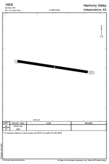
Runways:
| RWY identifier | QFU | Length (ft) | Width (ft) | Surface | LDA (ft) |
| 09 | 98° | 2100 | 60 | GRASS | |
| 27 | 278° | 2100 | 60 | GRASS |
Airport contact information
Address: Independence United States