


13Q - Jewett Mesa
Located in Apache Creek, United States
ICAO - 13Q, IATA -
Data provided by AirmateGeneral information
Coordinates: N34°0'16" W108°40'47"
Elevation is 7681 feet MSL.
Magnetic variation is 12° East View others Airports in New Mexico
Operational data
Special qualification required
Current time UTC:
Current local time:
Weather at : KJTC - Springerville Muni ( 60 km )
METAR: KJTC 250355Z AUTO 29004KT 10SM CLR 09/M04 A3013 RMK AO2
Communications frequencies: [VIEW]
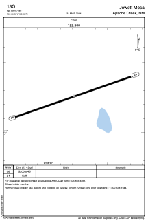
Runways:
| RWY identifier | QFU | Length (ft) | Width (ft) | Surface | LDA (ft) |
| 06 | 71° | 5200 | 45 | EARTH | |
| 24 | 251° | 5200 | 45 | EARTH |
Airport contact information
Address: Apache Creek United States