


12D - Tower Muni
Located in Tower, United States
ICAO - 12D, IATA -
Data provided by AirmateGeneral information
Coordinates: N47°49'5" W92°17'10"
Elevation is 1370 feet MSL.
Magnetic variation is -01° East View others Airports in Minnesota
Operational data
Special qualification required
Current time UTC:
Current local time:
Weather at : KCQM - Cook Muni ( 30 km )
METAR: KCQM 250115Z AUTO 00000KT 10SM CLR 09/M06 A3015 RMK AO2
Communications frequencies: [VIEW]
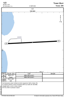
Runways:
| RWY identifier | QFU | Length (ft) | Width (ft) | Surface | LDA (ft) |
| 08 | 87° | 3400 | 75 | ASPH | |
| 26 | 267° | 3400 | 75 | ASPH | |
| 14W | 0° | 5000 | 200 | WATER | |
| 32W | 0° | 5000 | 200 | WATER |
Airport contact information
Address: Tower United States