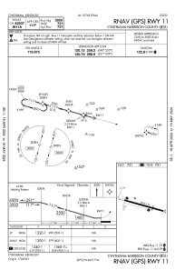
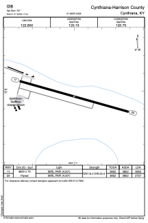


0I8 - Cynthiana-Harrison County
Located in Cynthiana, United States
ICAO - 0I8, IATA -
Data provided by AirmateGeneral information
Coordinates: N38°21'58" W84°17'0"
Elevation is 721 feet MSL.
Magnetic variation is -06° East View others Airports in Kentucky
Operational data
Special qualification required
Current time UTC:
Current local time:
Weather at : KIOB - Mount Sterling/Montgomery County ( 43 km )
METAR: KIOB 251135Z AUTO 00000KT 10SM CLR 03/01 A3030 RMK AO2 PWINO
Communications frequencies: [VIEW]
Runways:
| RWY identifier | QFU | Length (ft) | Width (ft) | Surface | LDA (ft) |
| 11 | 106° | 3850 | 75 | ASPH | 3852 |
| 29 | 286° | 3850 | 75 | ASPH | 2757 |
Airport contact information
Address: Cynthiana United States