


0A8 - Bibb County
Located in Centreville, United States
ICAO - 0A8, IATA -
Data provided by AirmateGeneral information
Coordinates: N32°56'13" W87°5'26"
Elevation is 251 feet MSL.
Magnetic variation is -02° East View others Airports in Alabama
Operational data
Special qualification required
Current time UTC:
Current local time:
Weather at : KEET - Shelby County ( 39 km )
METAR: KEET 251953Z AUTO 32003KT 10SM CLR 27/12 A3010 RMK AO2 SLP187 T02720117
TAF: KEET 251720Z 2518/2618 VRB03KT P6SM FEW040 BKN250 FM261400 15007KT P6SM BKN250
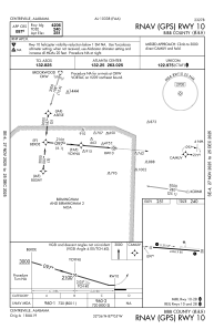
Communications frequencies: [VIEW]
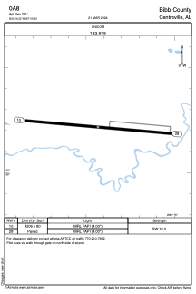
Runways:
| RWY identifier | QFU | Length (ft) | Width (ft) | Surface | LDA (ft) |
| 10 | 95° | 4206 | 80 | ASPH | |
| 28 | 275° | 4206 | 80 | ASPH |
Airport contact information
Address: Centreville United States