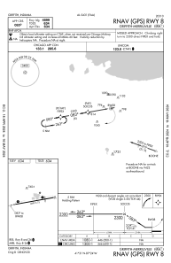
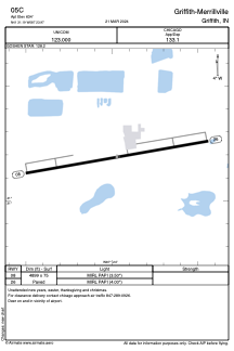


05C - Griffith-Merrillville
Located in Griffith, United States
ICAO - 05C, IATA -
Data provided by AirmateGeneral information
Coordinates: N41°31'11" W87°23'58"
Elevation is 634 feet MSL.
Magnetic variation is -03° East View others Airports in Indiana
Operational data
Special qualification required
Current time UTC:
Current local time:
Weather at : KGYY - Gary/Chicago Intl ( 11 km )
METAR: KGYY 240145Z 25010G23KT 10SM BKN075 OVC090 13/13 A2985 RMK LTG DSNT NE
TAF: KGYY 232334Z 2400/2424 22014G24KT P6SM VCSH FEW015 BKN050 FM240200 27012KT P6SM BKN100 FM240500 36015G25KT P6SM SCT025 FM240700 01014G24KT P6SM BKN020 FM241700 02012G20KT P6SM SCT035
Communications frequencies: [VIEW]
Runways:
| RWY identifier | QFU | Length (ft) | Width (ft) | Surface | LDA (ft) |
| 08 | 80° | 4899 | 75 | ASPH | |
| 26 | 260° | 4899 | 75 | ASPH |
Airport contact information
Address: Griffith United States
